In this article we will be taking a broad look at one of the most important skills for any outdoor enthusiast, traveller, adventurer, hiker, sailor or soldier, and that is navigation and being able to find your way.
From the day we start to crawl, we begin to construct a mental picture of where things are and how to get to them. As we grow up, the distances we travel from our immediate surroundings become increasingly greater, and therefore the importance of being able to find our way back again also grows.
Since ancient times, man had to navigate to find food, water, shelter and resources. The ability to find his way to any given place and more importantly back again was, and still is, a critical skill.
Natural selection dictated that those animals and humans that were unable to work out a way of getting to where they needed to be in order to survive did not contribute to the next generation’s gene pool.
What is Navigation?
Navigation can be defined as the process or activity of accurately ascertaining one’s position, then planning and following a route or course either by land, sea or air to your objective.
There are two general methods of navigation;
Navigating or finding your way with the use of instruments, tools and technology (Modern navigation) eg. map and compass or GPS (Global Positioning System), or navigating and finding your way using nature (natural navigation) without the aid of tools or instruments eg. using the sun, stars, moon, plants, weather, animals etc.
Both ways are not mutually exclusive and should be used in conjunction with each other.
The importance of being able to navigate and find your way
The ability to navigate across country by day and night is an essential skill that must be mastered. Many survival situations begin from people making navigational errors, or not being able to read a map or compass in the first place. In a survival situation you will be faced with many tough decisions. You may have to decide whether to stay where you are and await rescue, or move to an area that offers a better chance of survival and rescue. Your ability to navigate effectively, whether by using a map and compass or by using natural navigation, play a major role in your decision-making process.
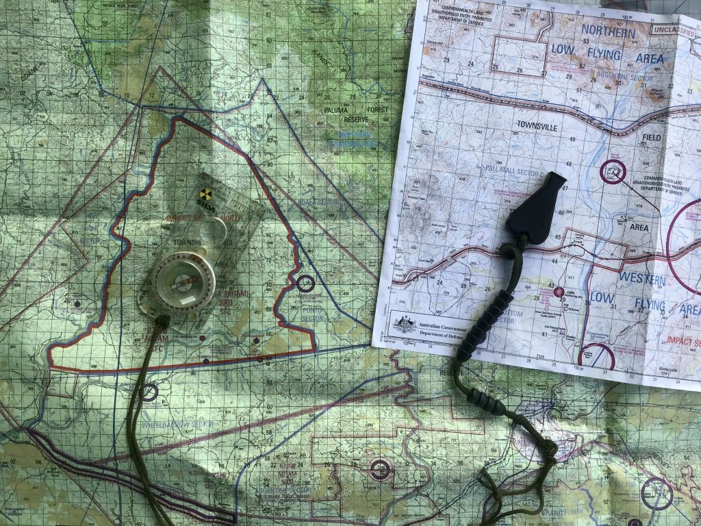
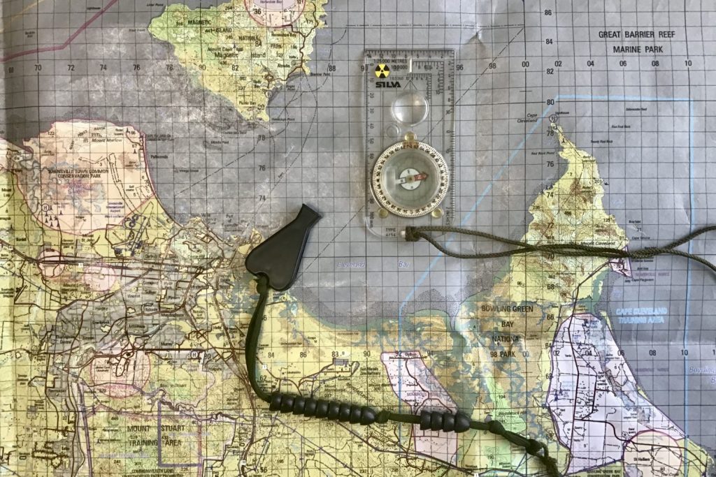
Map and Compass
Before you set off on a trip or adventure, you should have at least a basic understanding of how to read a map and use a compass. Your ability to correctly assess a map of the area you intend to visit will allow you to make informed decisions while preparing for your trip. If you understand the area and terrain, your chances of getting lost will be greatly reduced.
Being able to use a map and compass will enable you to plan the safest and most appropriate route, locate water, shelter and areas that will allow you to use your signalling aids properly. If you are proficient with a map and compass, you’ll have no cause to worry about getting lost or straying off track and will be free to enjoy your outdoor experience. Using a map and compass correctly is a separate skill set in and of itself and far too involved to cover in this short article, so we will take a look at some key areas in another issue. Some of the many sub-areas to be studied and understood include;
Map: mapcraft (being able to relate the map to the ground and the ground to the map), map scales, the map’s marginal information (legend, contour lines, north point diagram, grid magnetic angle), grid references, measuring distances, orientating the map, plotting bearings
Compass: using a compass roamer, taking a bearing, converting a bearing to a grid bearing and vice versa, magnetic declination, back bearings, walking on a bearing, resections, pacing and aiming off.
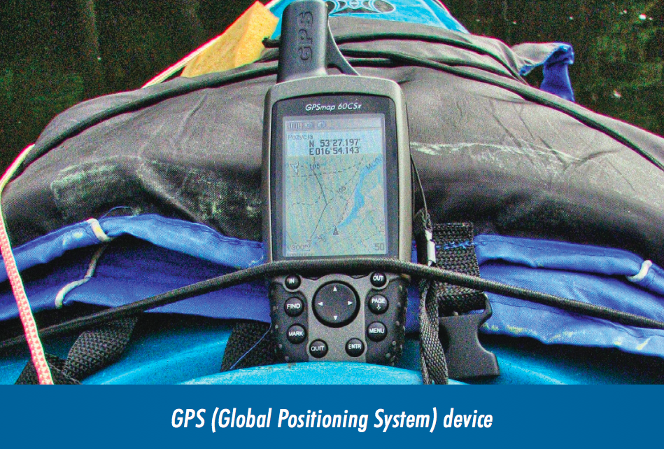
GPS (Global Positioning System)
GPS is a global satellite-based navigation system consisting of 24 orbiting satellites that provide location, velocity and time synchronisation to a GPS receiver anywhere on or near the earth where there is an unobstructed line of site to four or more GPS satellites.
GPS is everywhere – every time you use Google maps, or ask Siri for directions, you are using the GPS. Sadly, people these days are becoming increasingly lazy and are far too dependant upon technology, so they don’t know what to do when it stops working. GPS should be used as a backup navigation method and NOT be relied upon as the sole means of pinpointing your position, or for navigation. Learn to navigate with a map and compass and use GPS (if needed) as an aid to check your position. This is how we use it in the military. Never depend on technology and equipment that relies on batteries, especially in a survival situation, as both of these can fail!
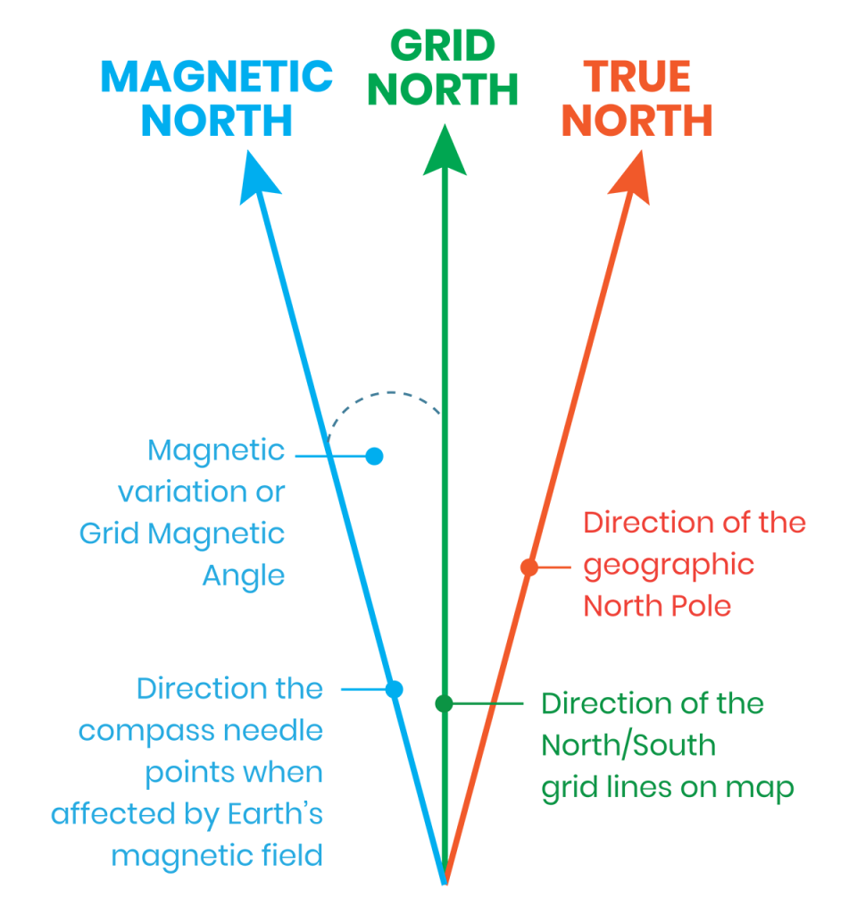
The Three Norths
Map legends refer to north in three ways; true north, grid north and magnetic north.
True North is the direction of the geographic north pole. Lines of longitude converge towards each other at the North and South Poles and are known as meridians. These lines are not parallel.
Magnetic North indicates the direction the compass needle points when it is affected by the earth’s magnetic field. The magnetic pole is not the true north pole. There is a variation between true north and magnetic north at any place. This difference is known as magnetic variation.
Grid North is the direction in which the north/south grid lines point towards the top of a map. They are parallel, unlike the lines of longitude using true north which are not. The variation between grid north and true north is called grid convergence and the angle between GN and TN is known as the grid magnetic angle. This needs to be calculated when using a map and compass.
Natural Navigation
Natural navigation is the art of finding your way by using nature. It is a process of observation and deduction involving the rare skill of being able to determine direction without the aid of instruments or tools, and only by reference to natural clues including the sun, stars, moon, land, sea, weather, wind, plants and animals.
FINDING DIRECTION USING THE SUN AND A SHADOW STICK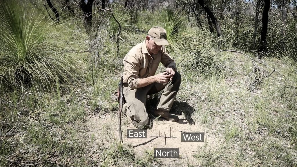
The sun moves across the sky from east to west (right to left in the southern hemisphere) in the northern part of the sky (below the tropic of Capricorn) at a rate of 15 degrees every hour. If you place a “straight” one metre long stick vertically in a flat area of ground that is in the sun, a shadow will be cast by the stick.
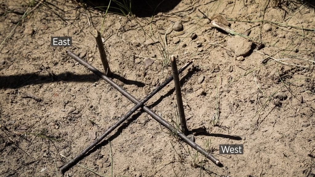
Mark the end of this shadow with a small stick or stone – this first marker will be your westerly marker. Wait a minimum of 20 minutes and the shadow will have moved. Mark the new shadow tip with another small stick or stone.
By joining these two markers together with another straight stick, you will produce an east/west line. North and south will be 90 degrees to this.
The longer you wait, the more accurate this will be. If you were to mark the changing shadow tip over the course of a whole day, you would find that depending on the time of year you’ll either get a long straight line created by the markers around the two equinoxes (21 March, 21 September), or a curved line around the two solstices (21 June, 21 December).
WATCH THE VIDEO HERE
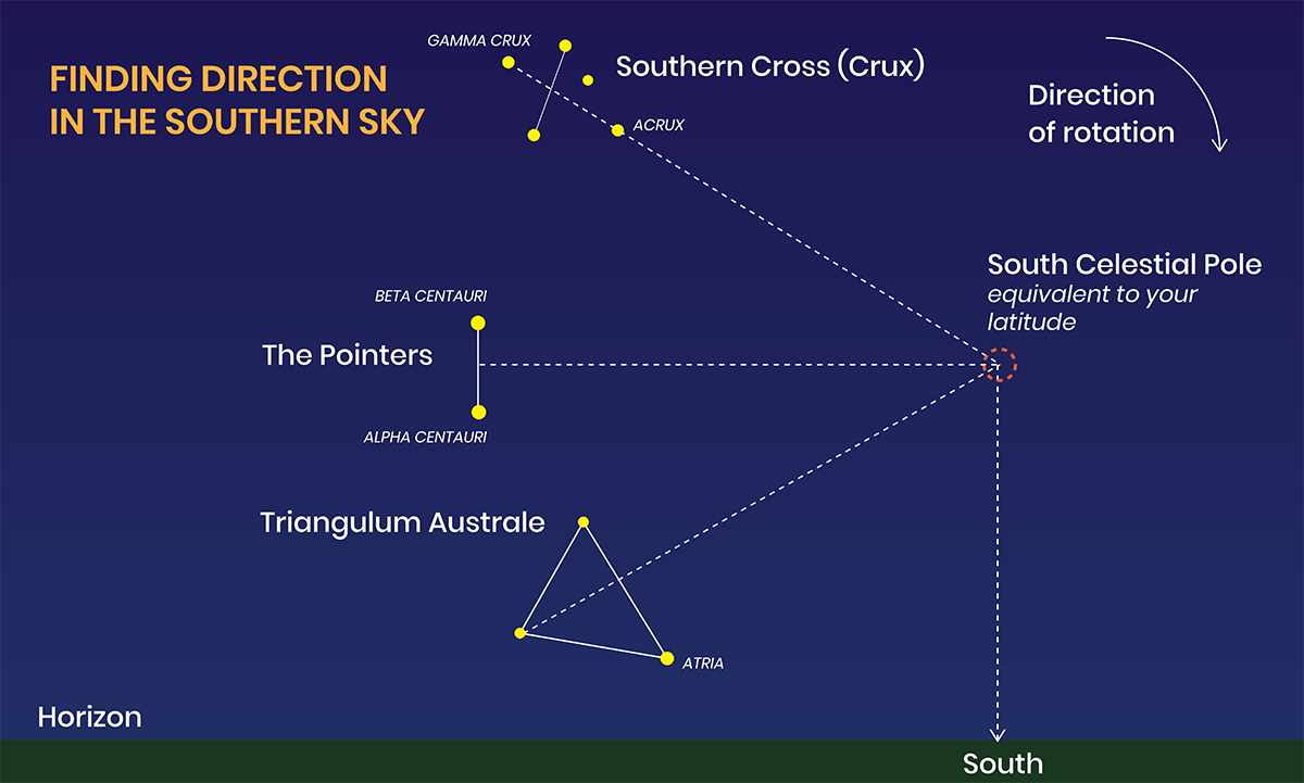
FINDING DIRECTION USING THE SOUTHERN CROSS AND THE POINTERS
Due to the rotation of the earth, all celestial bodies rise in the east and set in the west. If you are looking east, stars will appear to rise upwards. If you are looking west they will appear to fall downwards. If you are looking south, the stars will appear to move to the right and circle clockwise around the south celestial pole, and if you are looking north they will appear to move to the left and circle anti-clockwise around the north celestial pole (which we can’t see in the southern hemisphere).
In the southern hemisphere we don’t have a star that marks the position of the south celestial pole like the north star (Polaris) does in the northern hemisphere. In order to find the south celestial pole and therefore find south, we need to guesstimate this position using two well-known constellations, the Southern Cross and the Pointers.
Locate the Southern Cross and draw an imaginary line along the long axis of the cross (crux) and continue it out. Now locate the two bright Pointers, draw an imaginary line between these two stars, and at the centre of this line draw another imaginary perpendicular line, continuing it out until it joins the imaginary line from the southern cross. The intersection of these two lines marks the Southern Celestial Pole, where all the nearby celestial objects will appear to rotate around it in a clockwise direction. To find south, simply drop a line downwards to the horizon.
The angle between the horizon and the south celestial pole is also equivalent to your latitude.
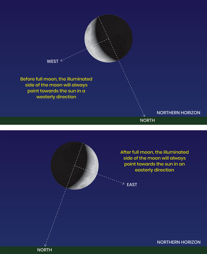
FINDING DIRECTION USING THE MOON
The moon also rises in the east and sets in the west, however due to its orbit around earth and the earth’s orbit around the sun, the moon lags behind the sun 12.5 degrees (50 minutes) each day. To use the moon effectively, you need to understand the various moon phases.
Put simply, the sun and moon are together in the same place in the sky at the new moon, so you can’t see the moon at this time. After 7 days, the moon is a 1⁄4 moon (almost 90 degrees behind the sun). At full moon (14 days) it is 180 degrees behind the sun (that’s why it is bright and full), 3⁄4 moon is 270 degrees behind, and then we have a new moon again at 28 -29 days where the sun has caught up with the moon and the cycle begins again.
The illuminated side of the moon always points in the direction of the sun. In the southern hemisphere, before full moon, this will always be the left side of the moon pointing to the sun in the west. After full moon, the illuminated side of the moon will be the right side of the moon pointing to the sun in the east. If you join the tips of a crescent moon with an imaginary line and continue that down to the horizon, this will point in a northerly direction in the southern hemisphere. The sun will therefore be 90 degrees to this line.
“Maps/Compasses and Natural Navigation are not mutually exclusive and should be used in conjunction with each other”
Planning
Before you venture into an unfamiliar environment, ensure you have a good quality compass made for your geographic region. You should also have reliable topographic maps in different scales of the area you are visiting, carefully research the type of terrain you will be encountering, and investigate the best method of travelling safely and efficiently across it.
Simply checking the weather forecast before you go will also allow you to evaluate conditions and make informed decisions before you travel. The ability to assess your situation and modify your plans means that you will be able to avoid many potential survival situations.
In later issues we will look more specifically at navigation using map and compass, and take a closer look at natural navigation.
No Comments